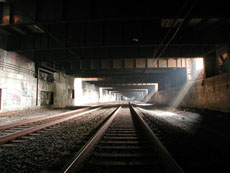
Photograph by Steve Duncan
LIVING DEEPLY IN NEW YORK
Steve Duncan dredges up images of the urban underneath
By Ryan Hagen
Photographs by Steve Duncan / undercity.org
There are no Google maps to mark where Steve Duncan has gone: into the buried rivers, renounced aqueducts, and forsaken tunnels that make up the deep places of New York. And that’s the attraction for this 29-year-old photographer and urban explorer, whose mission to document what lies beneath this city gives another meaning to the term “off the grid.”


Descending into these illicit depths — many of them just a few dozen feet below some of the busiest intersections in the world — there’s a sense of solitude, of being at the gnarled root of things.
“You should see New York as a three-dimensional construct,” he says. “It’s not just a two-dimensional surface on which we map our lives.”
Most of us think of New York as a vertical city. We travel along its streets, we dip into its subways, and climb into its skyscrapers. But Duncan wants to push us beyond our comfortable, conventional elevations to experience “a feeling of otherworldliness, of being outside the normal range of what you see. Everyone’s seen subway tunnels, but when you’re walking down one, you feel totally out of place. I love that feeling. It's totally energizing. It makes you more aware of the city around you.”
Flipping through the photographs Duncan has brought back from the underground, you start to understand what he means. Here is a New York without people, a wilderness beneath our feet. Descending into these illicit depths — many of them just a few dozen feet below some of the busiest intersections in the world — there’s a sense of solitude, of being at the gnarled root of things.
What Duncan has photographed are not quite ruins, not even the disused lengths of the Old Croton Aqueduct in the Bronx, which was celebrated as an unprecedented marvel of civic engineering when completed in 1842. The day the aqueduct opened, its chief engineer, John Jervis, took a rowboat down the aqueduct’s entire 41-mile length, emerging in Central Park to cheering crowds, which included then-President of the United States John Tyler. Today it sits abandoned, bricked over and all but inaccessible. But in Duncan’s photographs, the aqueduct appears essentially intact, a bit of vestigial infrastructure beckoning adventurers to retrace Jervis’ path.
It’s that sense of history that is most alluring to Duncan. Underground, he says, “you see things themselves as having their own paths in history.”
And that history reaches back far before the Old Croton Aqueduct. Duncan’s current project is an exploration of the 200 or so rivers and streams that still flow beneath the five boroughs. These waterways once crisscrossed the New York area, but as the city grew they were buried in stone-lined trenches, bricked over and mostly forgotten. In exploring them, “you see something that predates the city,” Duncan says. “It’s not the same water, it’s not even the same course, because it’s been walled in with stone. But it’s a piece of the topography that was there before any part of the city was.”
Duncan says his mission is to bring that joy of rediscovery to a wider audience. He is at work on a book of photographs taken from the depths and heights of the city. Think of it as a new kind of guidebook. As Duncan says, “You don’t know a city until you’ve been under it and above it.”
Please write us at newyorkmoon@gmail.com


